Skip to content

R4S

Rethinking Research for Schools

  • Home
  • About
    • Our Team
    • Advisors
    • Partners
  • Our Work
    • Framework
      • Depth of Use
      • Gaps in Use
    • Measurement Study
    • Descriptive Studies
    • Research Brokerage Study
  • Evidence & ESSA
  • Blog
  • Resources
  • Publications
  • Presentations
  • Newsroom
  • Contact
A map of the United States shaded in blue, organe, and red to reflect every state's ESSA plans status with the United States Department of Education. Red shading represents the draft plan was released. Orange represents the plan was approved by USDOE. Blue shading represents the plan was submitted to USDOE.

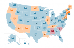
State ESSA Plans | Interactive Map

Posted on September 27, 2017November 20, 2019 by Dan Jircitano

Choice Media's interactive map tracks state ESSA plans by their status with the United States Department of Education and links visitors to the latest version of each state plan.

View the map>

Posted in ESSA

Published by

Dan Jircitano

View all posts by Dan Jircitano

Post navigation

Previous Post Understanding ESSA | Website
Next Post A Guide to State ESSA Plans: Goals, Teacher Quality, and More

Stay in Touch

Email
crue-info@udel.edu

Twitter
@Rsrch4Schls

Address

Pearson Hall
University of Delaware
125 Academy Street
Newark, DE 19716

Funding

The research reported here was supported by the Institute of Education Sciences, U.S. Department of Education, through Grant R305C150017 to the University of Delaware. The opinions expressed are those of the authors and do not represent views of the Institute or the U.S. Department of Education.

© Pena Theme by Anariel Design.